Tuesday's Tip - GPS and Tombstones
- Cherie Cayemberg
- Aug 1, 2023
- 4 min read

I've been using FindAGrave.com and BillionGraves.com for years. I used to snap photos at cemeteries for transcription with BillionGraves. I loved the thought that a fairly exact location could be attached to a tombstone. It was comforting to know that my descendants would be able to find our ancestors this way. I didn't really use the FindAGrave app. Just the website, so I didn't realize that you could do the same thing with their app.
I haven't used BillionGraves in a little while because I had an internal falling out with them. What does that mean? It means I found out that they take the photos we snap and upload and copyright them. I then ranted and raved to myself and stopped contributing. Internal falling out.
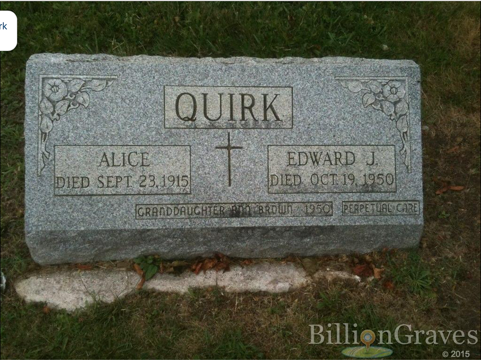
I had been getting ready to write a blog post and went to grab a photo from one of the tombstones I uploaded and saw that copyright slapped onto it and I found out quickly that you can't download the image from the page. The image of the Quirk tombstone to the right is a screenshot....complete with the copyright that gets my ire up every time I see it.
The nice thing about FindAGrave was that people could add images to memorials (even if they didn't create the memorial) and you can download them. When I'd want to use a photo that I didn't take from FindAGrave, I'd just click on the name of the person who submitted it and ask permission. FindAGrave also connects to Ancestry.com so when you're using them for your research, you can link a memorial to your tree. Not something I've seen happen with BillionGraves who appears to work with FamilySearch or at least when you go to edit a memorial there is a spot for a FamilySearch person ID.

Now let me steer out of that tangent and get back to GPS and tombstones. When I went home this summer I went to St. Gabriel's Cemetery in Hazleton, Pennsylvania. My youngest son, mother, and I were planting bulbs and cleaning headstones. I decided to grab the grid coordinates for the tombstones I was working on and put them in their FindAGrave memorials once I got home. I still hadn't realized that I could do this through the FindAGrave app. I used the compass app on my phone and this is what I got (and I'll continue to use Edward and Alice Quirk nee Blanchfield for this post).
I did not realize (and should have) that this was not going to give an accurate location. I didn't realize it until I went to input the data into the memorial on FindAGrave and that led to another discovery as well. You need to convert the degrees, minutes, and seconds reading seen here to a decimal lat/long and unless there's some trick I don't know about (which is very possible) you need a site to convert that. I used GPSCoordinates.net to convert this. I then entered it into the memorial and hit the map teardrop to see how close it got.
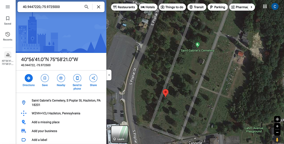
That's not where their tombstone is. I mean it's close but by that I mean about 50-100 feet near there. So I decided to go to BillionGraves and see how close their map was. After all I knew I had contributed for this grave...

I couldn't find a satellite mode for their map and that didn't make me particularly happy, but comparing it to the shot from FindAGrave I can at least tell that it's much closer to correct.
When using the apps you can navigate to tombstones and that makes both the FindAGrave and BillionGraves apps invaluable. Here's the thing though...I'd love to think that these sites/apps will be available generations down the line, but I'm not willing to pin future navigation to my ancestors' graves on a hope. That and and BillionGraves gives up nothing so their more accurate reading than what I inputted in FindAGrave isn't helpful. They aren't giving you the grid coordinates to find jack outside their app/site. So if you'd like that information to keep in your family tree, that's just too damn bad. Proprietary. FindAGrave is not like that...

As I mentioned those coordinates aren't accurate and that is totally MY fault and not FindAGrave's so I'll be removing them until I can get better coordinates to contribute, but the point is you can actually see the coordinates! I went to Alice's memorial in a browser where I wasn't logged in to my account to make sure I was seeing what everyone else would see and I hovered over the teardrop/show map and the GPS coordinates appeared! So I could go to each memorial for someone in my tree and save those coordinates.
Now I certainly don't think that all this great information is going to disappear if either or both of those sites fail. I think that there would be an effort to preserve it, but I don't want to be stuck on the wrong side of a paywall in the future or have it in a location that my descendants won't find it.
FamilySearch is awesome, but I just don't use it often. Since my tree is on Ancestry I do most of my research there so FindAGrave makes more sense for me. Plus they don't irritate me by making everything proprietary. They seem to understand that what they have created happens because of volunteers and they aren't trying to keep us out from retrieving that information.
So what if you don't want to use either FindAGrave or BillionGraves and I've already shown how terrible the compass app on an iPhone is? Well, there are other apps and gadgets for that. My husband uses a GPS for geocaching (and apps, of course) and if you have one you could use it to get the coordinates for your ancestors' tombstones. There is also an app called "MyGPSCoordinates." There is a free version and a paid version. You cannot save coordinates with the free one, but if you're willing to write them down as you go through a cemetery you don't need that capability. The free version also gives you the ability to convert immediately to a decimal lat/long and even UTM coordinates with just a touch. I'm sure there are other apps, but this is just the one I found and I like free.


Comments